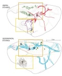
 A nice find, and a nice story: “hunter-gatherers may have had had their own maps. A team of archaeologists have matched etchings made 14,000 years ago on a polished chunk of sandstone in northern Spain to the landscape in which it was found. They claim to have the earliest known map of a region in western Europe – a prehistoric hunting map.
This spectacular find may give a glimpse into the way people navigated and explained their territories. Nevertheless, “the interpretation is, of course, pure speculation, as with all other such claims for Ice Age maps,” says archaeologist Paul Bahn. “On the other hand, it would be extremely surprising if these people did not produce rough maps. They were as intelligent as we are and were constantly moving around the landscape.” He agrees the stone is the best bet for a prehistoric western European map so far. According to Jill Cook, head of the prehistory division at the British Museum in London, hundreds of similar etchings have been found sprinkled across Europe.”

Full story: http://www.newscientist.com/article/mg20327204.400-found-a-pocket-guide-to-prehistoric-spain.html
Tags: Ancient map, Archaeology, British Museum, hunter-gatherers, Ice Age maps, Jill Cook, Paul Bahn, prehistoric Spain, sandstone
Leave a comment